No End to Annual Fury of Floods in Assam! Why?

Come Monsoon in June annually, the fury of floods in Assam becomes the “Breaking News Headlines” in almost all TV Channels.
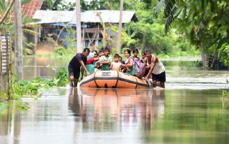
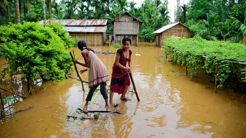
Assam is in the grip of yet another flood, with 59 dead and 48.87 lakh people affected in 27 of the 33 districts of the state as per Assam State Disaster Management Authority (ASDMA) report in media. In terms of impact on human lives, the floods of 1988, 1998, 2004 and 2012 were the worst; the 2004 floods alone affected 12.4 million people and claimed 251 lives.
Floods are a regular annual feature in Assam. As per experts, Assam experiences two to three flood waves until the end of the rainy season, which will last till mid-October. This is the first wave of floods this monsoon, and flood control experts expect at least two more.
In reality, annual floods in Assam are mostly man-made ones — deforestation, population growth in catchment areas, habitation in adjoining low lying areas, earthquakes and landslides and large road construction activity. Some years witness more destruction than others.
Why are floods so destructive in Assam? The reasons for destructive floods commonly identified by environmentalists include: heavy rainfall spells during monsoon; discharge of 19,830 cubic meters of water per second, that is, fourth ranked in the World; and, annual sediment yield of 1,403 tons per sq km with 804 tons per sq km at Pandu of Guwahati.
And, the prime reason for vast sedimentation is ascribed to Tibet that is cold, arid and lacks plantation, which is patently wrong. But, what about sedimentation due to barren hills South of Watershed in Arunachal Pradesh and from North of Patkoi Range due to deforestation? Ascribing the reason for floods to Tibet is just indulging in ‘blame games’ on the neighbors.
With the glaciers and snow meltdowns, soil erodes and results in vast silt flowing downstream. With the first outbreak of Monsoon rains nowadays, water gushes in rapids from numerous tributaries into the Brahmaputra River in Assam valley carrying with it large sediments from the hills. Naturally, vast amounts of silt get deposited in the riverbed creating temporary sandbars or river islands and resulting in changes in the river course. Following swirling waters gushing gnawing away at embankments and bunds, adjoining low lying areas and inhabitations get submerged. There is nothing new about the above phenomena – pure and simple Natures Law.
Media barely goes into the causes of floods except for covering and sensationalizing episodic incidents. Look at the fraud reported in the media – China’s failure to provide meteorological data is responsible for the fury of floods in Assam. In the recent past, there is also controversy stirred by sensational news coverage on the first “Dam” constructed by the Chinese that became operational for power generation in 2015 upstream in Tibet - the Zangmu Dam on the Yarlung Zangbo/Tsang Po/Brahmaputra River 9 km (5.6 mi) northwest of Gyaca built a few kilometers from the Bhutan- India border.
Let me highlight the data of annual precipitation in Lhasa that is relatively high for Tibet at 500 millimeters (50 centimeters), whereas the annual precipitation across the region averages around 200 millimeters (20 centimeters). Most of the rainfall happens between June-September. Barely there is rainfall during other months.
In contrast, the highest annual rainfall for individual station south of the Himalayan Watershed may exceed 5000 millimeters (500 centimeters) and average number of rainy days (days with rain of 2.5 mm. or more) ranges from 100 at Thangu in North Sikkim to 184 at Gangtok in east Sikkim. Almost 10 times more than in Tibet!
De facto, the maximum rainfall is on the South of the Himalayan watershed year after year. Even a layman would laugh at the media blaming China or other nations for the fury of floods in the States of Assam, W. Bengal, Bihar and UP.
Yet another reason attributed is the earthquake-prone nature of the region that is responsible for the rivers unstable character. Following the devastating earthquake of 1950, the level of the Brahmaputra rose by two meters in Dibrugarh area in eastern Assam.
My first exposure to centuries-old primary forests – Natures Gifts - dates back to 1961, when I first started climbing the mountains to go on patrolling to the Mac Mohan line. It used to take me at least 30-40 minutes to reach and see the canopy of the tree at the top. With such a green canopy, only drops of rain driblets used to fall on us even when there was heavy rain.
And, the foliage under the trees and bushes used to absorb rainfall. Nature used to control its steady flow into streams and rivulets. So, in the first monsoon rains in May-June, tributaries were rarely flooded. Mostly the water used to be crystal clear. River water flows getting muddied due to sedimentation was mostly restricted to monsoon period during July-September. Today, all that has changed dramatically due to human greed.
Next, human greed is the prime reason for the repetitive annual devastation and destruction. Over the past 60 years, deforestation of large tracts of primary forests – tropical, sub-tropical, temperate, pine and alpine forests at various altitudes besides bamboo forests and grasslands – has been carried out in connivance with local political leaders by “Veneer and Saw Mills besides Plywood factories”.
In reality, uncontrolled deforestation is the main reason for devastating floods year after year. During my tenure in Mon District of Nagaland during 1985-1988, I was witness to devastation of centuries-old primary forests, particularly Hollong trees that grows naturally in forests of upper Assam and Arunachal Pradesh considered as the State Tree of Assam and sacred tree for Moran community.
Today Hollong forests are virtually denuded as they have been used for the sake of manufacturing plywood to decorate chambers and furniture. Similarly, centuries-old Holok trees have been cut for use by plywood industries. Over 75 Veneer and Saw Mills operated in the foot hills of astride the Assam-Nagaland border in Mon District. Subsequently, I also witnessed its spread to Arunachal Pradesh during 1995-1996 and the spread of deforestation with utter disregard to its adverse environmental fallout spread to all the Hill States to include Meghalaya, Mizoram, Manipur and even Sikkim. Similarly, deforestation of all other species used as fillers in making plywood.
Due to logging, mostly illegal and some legal, canopy cover and foliage water retention capability has substantially diminished. Its fallout is soil erosion resulting increased quantities of sludge flows into the main river resulting in changes in the course of main channel of rivers. With silt/sludge sedimentation drastically depositing in the main channel and reducing its depth and its capacity for flow of water, floods are natural what with swirling waters cutting into the banks, breaching bunds and overflowing inundating low lying areas devastating and destroying all that falls in their way.
Yet another significant factor to note is three to four times increase in population. For example, population of Assam in 1951 was only just over 80 lakhs; but increased to 3.2 crores in 2011, that is, four-fold increase. Less known is the fact that majority of the tea estates have been developed on elevated terrain features. Perforce, restricting space for human habitations to low lying flood prone areas is quite common. When rainfall is heavy and river banks are breached low lying areas get inundated resulting in flooding of human habitations and destruction and death to humans and animals.
Also, in the early decades of independence, people lived mostly in eco-friendly “Bamboo Houses” made on “Silts” as proactive and pre-emptive safety and security measure. With three to four fold increase in population and in the name of growth and development, human habitations – cement jungles - have been developed in low lying areas prone to inundation. Who is responsible for such thoughtless growth processes?
Yet another reason is the thoughtless development of road and railways infrastructure totally oblivious to the need to respect and allow natural flow of water to run their course.
What plans have been implemented in the past to ameliorate the flood distress in Assam? Building embankments and dredging are the two means used for short-term mitigation. Both measures have failed to provide assured mitigation.
Next, in its master plan on the river in 1982, the Brahmaputra Board thoughtlessly suggested that dams and reservoirs be built to mitigate floods. Construction of major dams north of river Brahmaputra in earthquake prone ecologically unstable areas is inviting disaster to happen. Engineering studies must explore the feasibility of constructing “Dams” South of river Brahmaputra. Be that as it may, in the past, locals and environmentalists had protested against major dam-building plans on grounds of displacement and destruction of ecology.
For example, the Brahmaputra Board proposal to build a multipurpose dam in the present Gerukamukh site where NHPC (National Hydroelectric Power Corporation) is constructing the Subansiri Lower Hydroelectric Project was put on hold due to objections by the Arunachal government due to submergence [concerns], which included a few small towns as well.
Next, dredging is yet another option to implement. But, it is cost prohibitive option on annual basis since silt gets deposited every year following floods.
Worse still, expert Meteorologists and technologists remain silent on the real causes. Surely, they have adequate past data available that can be used to carry out simulation studies to predict the fury of floods!
Viewed in such a hazardous environment, “integrated basin management” system to ideally bring in all the stake holder states on board, particularly Arunachal Pradesh, Nagaland, Meghalaya and even Bhutan, has been proposed sometime in the past.
It is a compelling imperative for such a Board to plan and implement projects on short, mid and long term context. In short term context, most critical is to impose ban on logging/deforestation activities in the Hill States of the Northeast. Also, execute construction of anti-flood bunds and de-silting of river beds by dredging at various intervals that can withstand the fury of ravaging waters and relief shelters.
Most immediate, however, it is to imaginatively start reforestation of degraded tracts particularly covering the barren tracts in the upper reaches on the Watershed with survivable alpine species.
Reforestation of denuded hill tracts is really a long term mitigating initiative with alpine species and Rhododendrons (down slopes of Chola Pass in Sikkim) particularly for high altitudes/terrestrial areas South of Himalayan watershed. Choosing the right tree/plant (Hybrids) for high elevation sites can mean the difference between planting success and failure. There are exhaustive research studies and recommendations available for selecting the right species for various altitudes. Hardly one has seen “Forest Nurseries” dedicated to supplying suitable species at various levels in high altitudes like the ones that exist on the Rock Mountains in Canada manned by Indians. What is needed, therefore, plans and implementation to develop forestry suitable for high altitudes in situ.
In view of the above, surely the blame squarely falls on successive ruling regimes and also people to disrespect nature. Sustainable development is utopia based on thoughtless and unimaginative laws and policies besides woefully inadequate effective implementation.
Never too late for even the current ruling parties and the government machinery to recognize their shortcomings and pass laws, make policies – proactive and pre-emptive – and ensure their effective enforcement ASP.
Otherwise, the same old stories and sensationalizing by news media of death and devastation would be repeated on annual basis. Let none suffer from illusions on the above count.