Post China calls Arunachal Pradesh 'South Tibet', now WHO names Ladakh as part of China
Total Views |
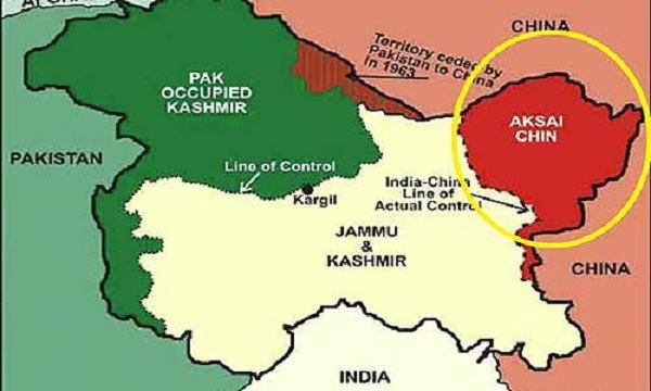
New Delhi, April 29: Following China's Sky Map claimed that Arunachal Pradesh is a part of 'South Tibet', it is now the World Health Organization that has displayed the parts of Ladakh (Aksai-Chin) are included in China's map in its website.

The WHO website has shown Jammu and Kashmir in different colors with Ladakh as part of Chinese territory with a dotted line and color code and Pakistan occupied Kashmir (PoK) is displayed with a dotted line, suggesting it as a “disputed territory”. Also, it has marked the territory that Pakistan had ceded part of PoK to China in 1963.
Several United Nations maps show parts of Kashmir as “disputed”, however, this might be the first time J&K and Ladakh are shown in different colors than the rest of India in the map of a UN body. It is reported that India has formally raised the matter with concerned UN authorities and awaiting a response.
Earlier, China had included some part of Arunachal Pradesh within its international boundaries as revealed by the latest version of Sky Map. Sky Map is China’s authority on digital maps that is a unit directly coming under the National Surveying and Mapping Geographic Information Bureau of China's capital Beijing.
A DW report in Chinese, some users of the Sky Map noticed it upgraded the geographic information at the county level. "The county boundaries of some counties clearly transcend the red color marked 1989 edition of the national border, especially in Tibet area bordering Bhutan and India,” the report had said.
On the other hand, China has already claimed its sovereignty over Tibet though Chayu, Medog, and Cuona counties are divided by the McMahon Line with the northern parts in China and the southern parts in India. It had through map called Arunachal Pradesh as part of ‘South Tibet’.

