NavIC 2.0: How India Permanently Unplugged Itself from America’s GPS
NVS-03 carries an indigenous rubidium atomic clock along with procured ones. That matters because clock failures were what troubled NavIC’s first generation, and India long depended on imported clocks.


True national sovereignty in the twenty-first century is not defined merely by secure territorial borders, but by complete control over the invisible digital infrastructure that powers a modern state. For decades, the global reliance on foreign navigation networks like the United States’ GPS left critical national capabilities from defense communications and precision missile guidance to civil infrastructure vulnerable to external strategic switches and unilateral denial. With the successful launch of the GSLV-F18 mission carrying the NVS-03 satellite, India has decisively closed that era of strategic vulnerability
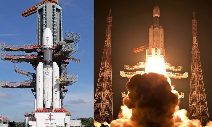
In an increasingly fragmented geopolitical landscape, this mission sends an unequivocal message: India is transitioning from a dependent consumer of foreign space infrastructure to an autonomous sovereign, guided entirely by its own sky.
The GSLV-F18 rocket is scheduled to lift off at 11.51 pm from the second launch pad at the Satish Dhawan Space Centre (SDSC-SHAR) in Andhra Pradesh's Sriharikota.
Why four satellites mean so much
Those systems belong to other countries. The US controls GPS and can degrade or restrict its signals in a region if it chooses. India has repeatedly pointed to this risk, and Kargil in 1999 is the example usually cited. A civilian convenience can become a strategic weakness at the moment a country most needs it.
🚨 ISRO CREATES HISTORY! 🇮🇳🚀
— Samjho India (@Samjhoindia143) October 31, 2026
India successfully launches the NVS-03 navigation satellite aboard GSLV-F18, strengthening our indigenous NavIC navigation system.
Another remarkable achievement by India’s space scientists. From innovation to excellence, ISRO keeps taking India to… pic.twitter.com/x9LogpHrxd
During modern conflicts, navigation data is as essential as ammunition. Precise guided missiles, unmanned aerial vehicles (UAVs), armored fleet maneuvers, and troop movements depend entirely on satellite positioning. Foreign governments retain the ability to degrade signal accuracy, encrypt civilian bands, or shut down access over specific geographic zones during crises.
NavIC was built to remove that weakness. It gives a standard service to everyone and a restricted, secure service for the armed forces and authorised agencies. Military operations, precision positioning and missile guidance can then rely on a signal that India controls. ISRO chief V Narayanan called it a strategic national asset giving independent access to position, navigation and timing services.
The clock inside the satellite
The most interesting part of NVS-03 may be its clock. Satellite navigation is really a way of measuring time. Each signal carries the exact moment it left the satellite. The receiver compares that with its own clock, and the tiny delay gives the distance. An error of one-millionth of a second puts the position off by hundreds of metres.
NVS-03 carries an indigenous rubidium atomic clock along with procured ones. That matters because clock failures were what troubled NavIC’s first generation, and India long depended on imported clocks. Narayanan said one of the homegrown clocks is already in orbit.
How many Congressis, leftists and comrades have posted about the successful #GSLVF18 launch and congratulated #ISRO?
— BALA (@erbmjha) October 30, 2026
The same people who never miss an opportunity to lecture India seem to go mysteriously silent when the country achieves something remarkable. pic.twitter.com/rltd4v78AR
The satellite will also help the ‘One Nation, One Time’ project. The government has recently notified the Legal Metrology (Indian Standard Time) Rules, 2026. A navigation constellation with its own atomic clocks can give banks, power grids, telecom networks and railways one official time, traceable to Indian satellites rather than foreign ones.
Interoperable L1 Civilian Band: Alongside the traditional L5 and S-band frequencies, NVS-03 transmits signals in the L1 frequency band—the standard band used by everyday civilian smartphones, personal tracking devices, and commercial receivers. This makes seamless integration with future consumer electronics faster, cheaper, and far more ubiquitous.
In short, the NavIC guarantees that India’s encrypted Restricted Service (RS) used by the Indian Armed Forces remains immune to foreign kill switches, third-party tampering, or signal jamming.
Precision Guided Weapons and Defense Integration
NavIC provides precision positioning across the Indian subcontinent and a 1,500-kilometer zone beyond geopolitical boundaries. This covers critical operational zones in the Indian Ocean, South Asia, and border regions, allowing indigenous platforms like the Agni and BrahMos missile systems to navigate using home-grown satellites.
The numbers
The launch was the 20th flight of the GSLV. NVS-03 weighs about 2,232 kg and was placed in a transfer orbit ranging from 170 km to 37,023 km above the Earth. Its own propulsion will now take it to a geosynchronous slot at 32.5 degrees East. ISRO flew it with the pyrotechnic valves of its propulsion system already open, a precaution described as unprecedented for the agency.
Narayanan said the mission came just 56 days after the previous GSLV flight, the shortest gap between two GSLV missions. He also said almost 80 per cent of the mission budget went to Indian industry. Both points suggest the capability now lies with Indian industry as well as ISRO.Union Minister of State Jitendra Singh called it an achievement that reflects India’s commitment to sovereign, indigenous navigation.
A milestone in India's navigational capabilities 🧭
— Himanta Biswa Sarma (@himantabiswa) October 31, 2026
The successful launch of @isro's GSLV- F18 has ensured that India's own navigation system, NaVIC is up and running again, eliminating dependence on foreign entities for mapping and shoring up the capabilities of our armed… pic.twitter.com/Fz2Ezq5Wvr
For decades, developing nations navigated through skies mapped and controlled by Western or Northern Hemisphere superpowers. When a country depends on foreign software, foreign silicon, or foreign satellites for its basic infrastructure, its sovereignty remains vulnerable to external pressures.
With the successful deployment of NVS-03 via the GSLV-F18 mission, India moves closer to self-reliance (Atmanirbhar Bharat) in space technology. By mastering indigenous atomic clocks, payload design, heavy-lift launchers, and advanced orbital mechanics, ISRO has demonstrated that Indian strategic decision-making will remain anchored solely to Indian national interests.
India's journey from seeking foreign satellite assistance during the 1999 Kargil crisis to operating its own navigation constellation over the subcontinent highlights a significant shift in national capabilities. The skies above India are now guided by home-grown innovation.